


The Struve Geodetic Arc is one of two UNESCO World Heritage Sites in Estonia.
The Struve Geodetic Arc, named after the renowned Baltic German geodesist Friedrich Georg Wilhelm Struve, is a remarkable monument of scientific achievement. Stretching across ten countries and covering a distance of approximately 2,820 kilometers (1,750 miles). This arc represents a groundbreaking effort to measure the shape and size of the Earth. With its inclusion in the UNESCO World Heritage List in 2005, the Struve stands as a testament to human ingenuity and collaboration.

The idea behind the Struve Geodetic Arc originated in the early 19th century when the field of geodesy was rapidly evolving. Struve, driven by his passion for geodesy and a desire to determine the Earth’s true shape, proposed an ambitious project to measure the meridian arc from the Arctic Ocean to the Black Sea. The purpose was to calculate the flattening of the Earth at the poles. Also provide a more accurate understanding of our planet’s dimensions.
The Struve Geodetic Arc and countries
One of the remarkable aspects of the Struve is the international collaboration it required. The arc spans through what are now ten countries: Norway, Sweden, Finland, Russia, Estonia, Latvia, Lithuania, Belarus, Moldova, and Ukraine. The project necessitated close cooperation among geodesists, astronomers, and surveyors from each country. They worked collectively to ensure the accuracy and consistency of the measurements. This cross-border collaboration demonstrates the commitment of the scientific community to push boundaries and expand knowledge.
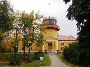
The Struve Geodetic Arc left an indelible mark on the field of geodesy. Its findings contributed significantly to our understanding of the Earth’s shape and provided a foundation for future scientific endeavors. In recognition of its historical and scientific significance, the arc was inscribed on the UNESCO World Heritage List in 2005. This designation highlights its outstanding universal value and ensures its preservation for future generations.
Efforts to preserve and promote the Struve continue to this day. Many of the original survey points and markers still exist, albeit some requiring restoration. Several countries along the arc have invested in their preservation, and educational initiatives have been launched to raise awareness about the arc’s importance. Tourists and enthusiasts can now explore sections of the arc, learning about its history and the scientific breakthroughs it represents.
UNESCO
The Struve Geodetic Arc is a testament to human curiosity, ingenuity, and the spirit of international cooperation. It stands as a testament to the pioneers of geodesy who worked tirelessly to measure our planet with remarkable accuracy. The arc’s inclusion in the UNESCO World Heritage List ensures that its significance will endure, inspiring future generations to continue pushing the boundaries of scientific exploration and understanding.